
I was incredibly excited about this project when it was introduced in our first class, but as the due date kept getting closer, I was at a total loss as to what I could possibly want to map, having both too many ideas and not enough ideas at the same time. I took a deep breath, and I thought, it’s almost Halloween (my favorite time of year), let’s draw some inspiration there. And that’s how I settled on cemeteries. Call it a morbid curiosity, but they’re some of my favorite places to visit. There’s a tension between remembering and forgetting, especially in older cemeteries. If there is no one living with memories of a person, is their headstone doing the remembering for us? Is that really the same thing as remembering, and is it enough? The headstones themselves are already reducing a whole life into a few data points: name, birth and death dates, and maybe a title/relationship, quote, or a decorative symbol. And what happens when even those data points are eroded away and are no longer readable by visitors? Is it enough to be in a dedicated place of the dead and know that its inhabitants once lived? What do I even mean by “enough”? What is the responsibility of the living to the dead?
Initial Premise and Data Search
I live in Queens very close to Calvary Cemetery, which claims the largest number of interments (about 3 million) in the United States, and it’s an incredibly massive feature in my daily landscape. So first and foremost, I was curious to know how much physical space cemeteries are taking up in New York City. Many of them must be full, or close to it; indeed, many of the cemeteries in Queens and Brooklyn were established when Manhattan burial grounds were facing a severe shortage of space, exacerbated by a cholera outbreak in 1847. What happens when the cemeteries in the outer boroughs fill up? Is the current land usage sustainable? In addition to urban planning concerns, there are also many environmental concerns about some of the more popular death rituals (burial and cremation), but I wasn’t sure how to include that here. I mostly was hoping to see the relationship between the space allotted for the dead and the rest of the city—the space allotted for the living (though admittedly cemeteries are perhaps more for the living than they are for the dead).
Based on the suggestion in class, I initially tried to find data on cemeteries from NYC Open Data; there were no search results. So I googled “cemeteries in NYC.” Most of the results feature a selection of the oldest, or forgotten/hidden, or most unique, or most notable dead. There are also websites like Find a Grave, where you can search for specific headstones in their database. But I wasn’t seeing any datasets showing all of the cemeteries in the city. So I decided I should start to make my own dataset from a Wikipedia listing and searching in Google maps (admittedly a problematic start). This quickly proved time-consuming and frustrating as many of the cemeteries listed don’t have entries in Wikipedia, and even cemeteries that have their own entries don’t always include information about area, or they contain measurements that are vague (e.g., qualified by “nearly,” “about,” “more than”). Not to mention I’m not sure who accumulated this list and how complete it is. From a cursory search, I know that there are cemeteries in Manhattan that have been built atop of (again see the 6sqft article “What lies below: NYC’s forgotten and hidden graveyards”)—sometimes with bodies relocated, and sometimes not. Should these count as cemeteries on my map? (I’m inclined to think yes.) I was also curious to see when the cemeteries were established, but even that proved to be a tricky data point. Does that mean when the land was purchased for the purpose? Or when it was incorporated? Or when the first bodies were interred?
From the outset, I’m already seeing that there is no neutrality in the data I’m collecting—a la Johanna Drucker’s “Humanities Approaches to Graphical Display”—and it’s time-consuming even to just find a list of cemeteries. So I immediately scaled back to just focus on Queens, and then I added in Brooklyn when I realized there are several cemeteries that span both boroughs.
Choosing a Mapping Tool and Creating My Map
I assumed that a static map rather than an interactive map would be easier to start with, having no experience in using mapping tools. I wanted to try to use an open access tool, so I immediately nixed ArcGIS and started with QGIS, but I realized that neither of the all-in-one release versions are compatible with my Mac setup. From the interactive map tools, I didn’t want to wait for approval access with Carto, so I opted to sign up for a free license of Tableau Desktop.
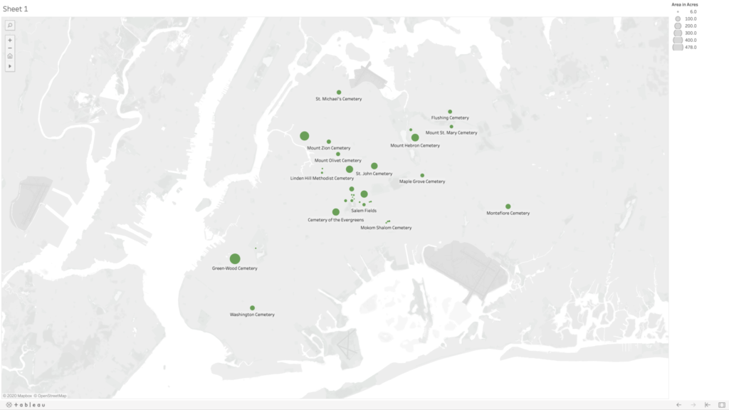
Very quickly, I was uploading my dataset, consisting of five columns—name, borough, geo coordinates, area in acres, and year established—and tried to make a map. I was dragging and dropping each of the columns into different fields in the Tableau workspace, but I was only able to get it to create graphs. I soon learned that the mapping would work better if I separate my geo coordinates into two separate categories for latitude and longitude (using the decimal values). After some trial and error, I figured out that you need to put longitudinal values into the columns category (y axis) and latitudinal values into the rows category (x axis), and finally I was seeing my cemetery dots. My original dataset had about 10 cemeteries in it, and my map was frankly looking really sad, so I decided to dig a little deeper and generate some more names and see if I could find info for the cemeteries without entries in Wikipedia. Thankfully I found the New York City Cemetery Project by Mary French. Through her research, I was able to fill my dataset out to 33 cemeteries in Queens and Brooklyn—there are very likely more as her project also includes historical information about potter’s fields and family burial grounds.
I used the area in acres category to be the scale, so that the dots appeared on my map on a size scale in relation to each other. Ideally, I would love this scale to relate to the scale of the map of the city in the background, but I could not figure out how to do this. Adjusting the scale is a matter of sliding a button up and down on a linear scale without any numbers, so I just picked a size scale that I found aesthetically pleasing. I’m also not 100% confident in my values for latitude and longitude as most of them were derived from my searching for the cemetery name in Google maps, and then right clicking “What’s Here?” for the values—and in doing so sometimes my mouse was clicking somewhere slightly different than where Google had placed it’s pin, and also Google sometimes seemed to have multiple pins for the same cemeteries, so I had to choose which to use, and sometimes it was placing pins near entrances and sometimes in the middle of the spaces. I also noticed there are many cemeteries that appear grouped together on the map, and there are instances where Google seems to be placing two pins in the same spot for two adjoining but different cemeteries.
Going back to NYC Open Data, I was able to find a dataset with information on all of the city parks, including area in acres. However, when I was trying to import this data to my map, I couldn’t figure out if the parks were in the correct location as that dataset was using different coordinates than I had used in my own dataset. Also, the acres column was coming through as a string rather than numbers—I cannot for the life of me figure out why—and so I have no confidence that what I was mapping for the parks was comparable in scale to what I had generated for the cemeteries, so I ultimately decided to scrap their data and just present my data on cemeteries in Queens and Brooklyn.
Ideas for Future Expansion
The first area of expansion would be to expand my map to all of the boroughs. Given the importance of having access to outdoor spaces—especially during the current pandemic—and knowing that picnicking in cemeteries was at one time a common practice, I would like to further dig into the visiting practices at each of these cemeteries (e.g., are visitors allowed, are visitations limited, have visitor policies changed during COVID-19?). And also find out how to map the cemetery spaces in comparison with other green spaces in the city. I’d also be curious to see the density in each of the cemeteries (number of interments compared with acreage) and average cost of burial.
In addition to urban planning and environmental concerns, I think cemeteries are a great starting point for discussions about access, community building, and even broader ideas of what it means to be human (and which people are “worthy” of remembering). Burials are expensive, and those without means have generally been buried differently—both in ceremony and location. And access to different cemeteries has been restricted based on other factors like race, ethnicity, and religion. A prime example is the African Burial Ground National Monument, whose original grounds included the remains an estimated 15,000 Black people—both enslaved and free. The original cemetery was closed and slated for redevelopment in 1794, later to be “rediscovered” and “re-remembered” when the land was being excavated for the proposed construction of a federal building in 1991. What does this purposeful forgetting of a cemetery mean for that group, and how do cemeteries contribute to our understanding/claims of belonging to certain communities and specific locations?

This entry is licensed under a Creative Commons Attribution-NonCommercial-NoDerivatives 4.0 International license.
This is a very interesting concept for map. I’m intrigued by your statement at the end – how cemeteries can offer insight into access, community building and what it means to be “human”. I had an experience searching for a relative in a cemetery and was told that if no one in the family continued for pay for maintenance, that the tombstone is probably not there anymore. It would also be fascinating to see demographics of the people in each cemetery and do a study comparing neighborhoods and time periods. As with so many of these map projects, the more I see, the more questions come up!