
I never used mapping software before, so I wanted to keep this project simple. I decided to use this DH tool to help me trace my family’s journey from the Dominican Republic to the United States. I wanted to highlight not just the trajectory but also how my family scattered across the country. Though this was my main goal, during the process, I discovered an interesting pattern that I wanted to continue to explore but couldn’t find a way to do using the map provided. I was about to give up on Arcgis (powered by Esri) software when I noticed their Story Map tool
.
CLICK BELOW FOR INTERACTIVE STORYMAP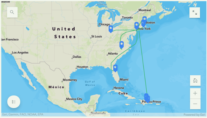
The Story Map tool allowed me to essentially, look at the story behind the map, the one I actually wanted to tell. While I was concern over the look and feel of the basemap and the layers (none that did the job I wanted ), I forgot about the bigger picture! The tool then so gave me the space I need it to tell my story and use the map more as supplemental material that supported my story and gave the audience a guided tour of the places and people mentioned. While creating the story I thought about Johanna Drucker, “Humanities Approaches to Graphical Display” and how to best add the human side to this data. I added photographs of my family members, where they were, and where they are now.
The first step was writing the story. My mother’s family started in a small rural area in the Dominican Republic called Jamo, La Vega. In the early 1960s, the family moved to the big city, Santo Domingo. My aunt subsequently came to the United States in the late 1960s and established a home in Washington Heights, New York City. Since then, the family hasn’t just grown but scattered to places like Columbus, Ohio, Boston, Massachusetts, and Orlando, Florida. When asked about why they either stayed in New York or left the city for more suburban and rural areas, they all mentioned an aspect of their home in Jamo and Santo Domingo. Both places hold many memories for each family member; they used this as a basis for their new homes here in the United States. While some want to maintain contact with their culture by staying near Washington Heights, others preferred to honor their live Dominican style by purchasing a home in Orlando and growing plantains and avocados, just like they did back in Jamo. My cousins in Jersey told me how much they missed having a backyard, space to host, and a large house to accommodate any family gathering similar to the home they had in Santo Domingo.
Once I wrote the story, I used the Express Map tool to add points and notes to the map. While I could pin a location and add a note, the difficulty came when using the line tool. I envisioned different colors the lines spreading from a single point (Washington Heights). However, the tool is limiting in that all points have the same color, and all the lines are of the same color as well, making it difficult to color-code each individual journey. The zoom in and out functions was also tricky and hard to control and focus making the process of adding the lines much more complicated.
The best part was adding the Guided Tour Map! I really enjoyed adding the photos that corresponded with each point of the journey/story. This tool, more than the Express Map one, gave the project a sophisticated look and added value to the points on the map; added faces to the points on the map. Overall, I feel more confident now to continue to use mapping software not just visualize stories, and journeys, but other data as well.
Currently, I’m using Inkarnate to create a fictional map for a fantasy story!

This entry is licensed under a Creative Commons Attribution-NonCommercial-NoDerivatives 4.0 International license.
I loved hearing about your family’s journey throughout the U.S. and I love that you have cousins in New Jersey, that is where I am originally from.
I find it fascinating that ARCgis won’t allow you to change the line color. Why do you think this limitation is? In my opinion, this is a very obvious thing that needs to be legible in a map and could cause problems for folks with visual challenges, and I would bet that many are not able to see the green line on top of the orange ocean.