
For the first mapping assignment I opted to learn how to use Tableau’s mapping feature. Since I am using the fourteen-day free trial some features were not available to me, so I will be posting screenshots of the map as well as the corresponding numbers per borough as the trial version does not allow me to publish a navigable link.
Since this was my first encounter with any mapping software some initial difficulties i faced were becoming accustomed to the user interface and how things were meant to work. Once I understood how to properly utilize Excel spreadsheets through Tableau and the different uses of CSV Excel spreadsheets and regular spreadsheets the process to map the data became clear. Through Tableau you are only able to map up to two geographical variables, so although the data I procured through the NYC Open Data Project’s website provided several different data, such as number of cyclists, motorists, pedestrians, etc. injured or killed, I chose only to map the most serious part of the data which was the total number of peoples killed or injured in motor vehicle accidents.
https://data.cityofnewyork.us/Public-Safety/Motor-Vehicle-Collisions-Crashes/h9gi-nx95
Above is the link to data and exportable Excel spreadsheets of data on motor vehicle accidents from 2015-2020. Attached below are the screenshots of the data I organized through Tableau and the final map. The file of the spreadsheets is too large to be posted here but can be easily accessed through the above link.

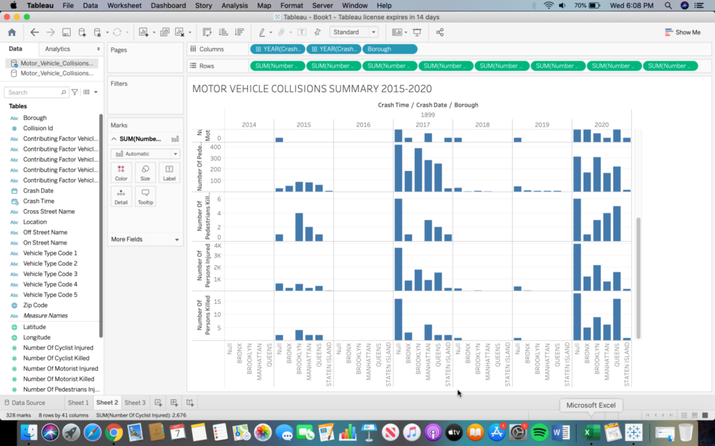

Above is the final map produced from the CSV Excel spreadsheet. The numbers represented by these orange dots are as follows:
BRONX: 30,292 INJURED, 89 KILLED
MANHATTAN: 27,194 INJURED, 129 KILLED
BROOKLYN: 62,936 INJURED, 238 KILLED
QUEENS: 51,090 INJURED, 223 KILLED
STATEN ISLAND: 7,037 INJURED, 36 KILLED (This data is negligible compared to the other boroughs and as such the dot over Staten Island is barely visible, despite the orange color.)
Although rudimentary, this first attempt at mapping anything has provided many valuable insights. These initial difficulties that I have been able to overcome will now allow me to move into mapping more sophisticated and personal data. I am interested now in mapping multiple variables with geospatial connotations as maps of this nature are usually the easiest to comprehend and the limit to what can be mapped geographically is nearly endless. I am unsure, however, of what software program to attempt next, as Tableau was straight forward and beginner friendly, but limiting in terms of mapping options.

This entry is licensed under a Creative Commons Attribution-NonCommercial-NoDerivatives 4.0 International license.