
For my praxis assignment, I attempted to create a map of James Baldwin’s short story, Sonny’s Blues. I reread the short story in search of particular locations or any evidence of areas Sonny and his brother could have occupied or visited in Manhattan. Because Baldwin was only fully descriptive about one location, I was forced to do some digging into the histories of Harlem, Greenwich Village, and midtown in the 1950s. After many rabbit holes and Internet dives later, I thought, maybe this could be an opportunity for me to use my creative license, basic knowledge of the city I grew up in, educated guesses, and some internet searches to fill the gaps? Perhaps provide an “extended version” of Sonny’s Blues? Though I was excited about this potential, I immediately grew terrified by the notion that this kind of power lies in the hands of actual cartographers and others responsible for shaping geographies of anything/any place. I was also overcome by guilt, which echoed my discrepancies with Roland Barthes’, The Death of the Author. How dare I mess with such important, masterful work? But, I decided to move forward with the intention of interacting and engaging playfully with a piece of text that I love and respect immensely.
Creating Locations:
In much of the scholarship I have read about Sonny’s Blues, the consensus seems to be that this story is not really about Sonny. But that it is, in fact, about the narrator of this piece—Sonny’s nameless, older brother. I found this to be true when attempting to pinpoint locations within this narrative. Of the handful of spaces I was able to pick out of the story, Sonny and his brother either occupied them together, and on one occasion Sonny was not present at all.
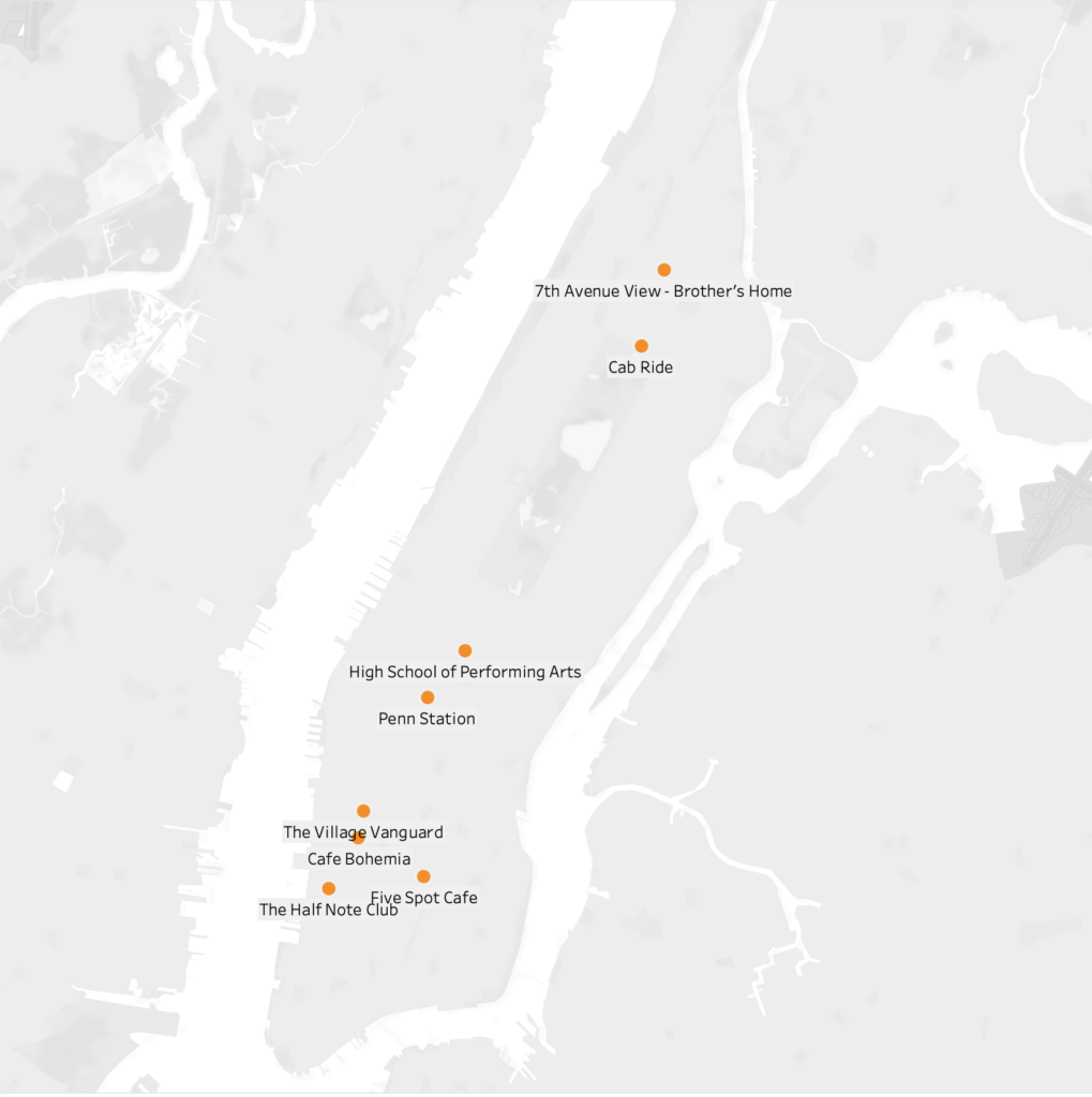
At the beginning of the narrative, after a train ride, we are introduced to our first location, the High School that Sonny’s brother taught in. Baldwin did not name this school or provide a location, but this is one of the places where I decided to do some educated guessing. In an interaction with one of Sonny’s friends outside of the High School, Sonny’s brother asks, “Did you come all the way down here to speak to me?” Clearly, this High School had to be somewhere below Harlem and far enough downtown to merit his confusion. This school should also exist within the decade this piece was written in. After doing a bit of research, the High School of Performing Arts on 120 W 46th Street popped up. The location of this school also fits the description of the surrounding area described in this scene.
My next location assumption came from the scene where the brother meets Sonny and picks him up from a location downtown. Sonny had been out of state in a rehab facility. Penn Station became my guess for this location since it is one of the only places that is a central location for bus or train rides in and out of the city. Once the brothers were in a cab heading uptown to Harlem, Sonny asks for the driver to take the Westside of Central Park for a more scenic route. Baldwin then pin-points their turn on 110th and Lenox Avenue. Sonny then says, “We are almost there”, which leads me to believe that that their end location is at the heart of Harlem on 125th Street. In a following scene Sonny’s brother mentions looking out onto 7th Avenue from outside of his window. Because of this, I chose to locate the brother’s home on 125th street and 7th Ave.
Lastly, in the final scene if this narrative, Sonny’s brother is watching him play in a Jazz joint somewhere in the village. This could have been any tiny nightclub location, but I wanted to map some possible Jazz clubs that existed in the village during that decade. I found a map online and narrowed it down to four possibilities: Half Note Club on 289Hudson Street (1957-1972), Five Spot Café on 5 Cooper Square (1956-1962), Village Vanguard on 7th Ave. South (1935-present), and Café Bohemia on 15 Barrow Street (1955-1960).
Again, this was mostly a guessing game, but I tried my best to use as much evidence within the piece as possible.
Mapping Software:
I am completely new to mapping or coding software, so I was immediately drawn to Tableau because of its beginner level accessibility. After downloading the software, I was still unsure of how to move forward, so I found a Tableau mapping tutorial on YouTube. As suggested, I created an Excel sheet for the names, addresses, and coordinates for each location. I then downloaded the excel information into the software. But after dragging the longitudes and latitudes into the row and column sections, the software kept placing a single coordinate in Antarctica (a long way from Harlem). After about 45 minutes of trying to problem solve, I realized I had mistakenly flipped the coordinates on the excel sheet, longitudes were under the latitude column and vise versa. After making this correction, the coordinates moved into Manhattan. I was relieved when I was able to successfully map these points, but I quickly realized that perhaps this is not the best mapping software for this kind of project. I would like to have been able to obtain a more detailed map of New York City and Manhattan in particular.
Conclusion:
The assignment made it even more obvious to me that our methodologies for collecting and disseminating data need to be set through humanistic and collaborative lenses. Also, though I am still uncomfortable with the software, it was nice to push through my fear and ground this practice in a text that it meaningful and important to me. I am not sure I’d be able to do it any other way.

This entry is licensed under a Creative Commons Attribution-NonCommercial-NoDerivatives 4.0 International license.